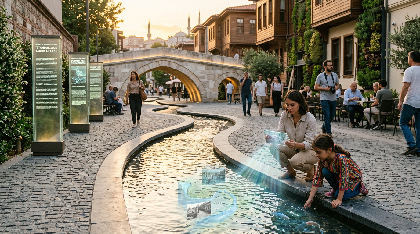
Istanbul Hidden Rivers: Tracing Forgotten Waterways & Urban Legacies in 2026
Beneath the bustling streets and ancient monuments of Istanbul lies a complex, often unseen, network of waterways. Many visitors are unaware that the sprawling metropolis, famous for the Bosphorus, is also crisscrossed by numerous Istanbul hidden rivers. These forgotten streams, once vital arteries of life, have been gradually covered, channeled, and integrated into the city's infrastructure over centuries, yet their legacy continues to shape the urban fabric and historical narratives of this magnificent city. In 2026, understanding these subterranean flows offers a unique perspective on Istanbul's enduring connection to water.
The Historical Significance of Istanbul Hidden Rivers
For millennia, water has been a fundamental element in the rise and survival of Istanbul, or Constantinople as it was known for much of its history. While the Bosphorus provided a strategic maritime route, the numerous smaller **Istanbul hidden rivers** and streams flowing from the surrounding hills into the Golden Horn and the Sea of Marmara were crucial for fresh water supply, agriculture, and local transportation. These waterways dictated early settlement patterns and the development of the city's impressive water infrastructure.

Byzantine Aqueducts and Cisterns: Taming the Flow
The Byzantine Empire, recognizing the importance of a reliable water supply for its capital, invested heavily in monumental engineering projects. Rivers like the Lycus (Bayrampaşa Deresi) and Cendere (Kağıthane Deresi) were sources for vast aqueduct systems that fed magnificent underground cisterns, such as the Basilica Cistern and Theodosius Cistern. These structures are testaments to how ancient engineers managed and repurposed natural **Istanbul hidden rivers** to serve a growing population.
Even today, when you walk through parts of the city, you might stumble upon remnants of these ancient aqueducts, hinting at the watercourses that once flowed freely beneath them. Their careful planning and construction ensured the city's vitality through various sieges and periods of expansion, a legacy that continues to intrigue historians and urban explorers in 2026.
Learn more about Istanbul's historical aqueducts on Wikipedia.Mapping the Subterranean Network: Where Do These Rivers Flow?
Pinpointing the exact routes of all Istanbul hidden rivers is a fascinating challenge for urban cartographers and historians. Many of these streams were not simply buried but were systematically channeled into underground culverts as the city expanded. The Lycus River, for example, once flowed through the historical valley that now hosts the city walls and various neighborhoods before emptying into the Golden Horn.
Other significant buried **Istanbul hidden rivers** include the Alibey and Kağıthane streams, which historically fed into the Golden Horn, forming a fertile delta. Over time, these waterways became integral to the urban fabric, often repurposed as sewage systems or forgotten beneath layers of concrete and asphalt. Understanding their original paths helps us trace the city's organic growth and the reasons behind specific urban planning decisions.

Urban Development and the Disappearance of Rivers
The intensive urbanization of Istanbul, especially in the 20th and 21st centuries, led to the covering of most of these natural **Istanbul hidden rivers**. As the city expanded outwards and upwards, rivers were seen as obstacles to development or as convenient channels for waste. This transformation, while facilitating growth, also erased much of the natural hydrological landscape, turning open rivers into underground conduits.
Today, these hidden waterways sometimes resurface during heavy rainfall, causing floods in unexpected areas, a stark reminder of their enduring presence beneath the city's surface. This phenomenon highlights the ongoing dialogue between nature and urban development in one of the world's largest megacities.
Exploring the Legacy: How to Discover Traces of Istanbul's Hidden Rivers Today
While you might not be able to kayak on these **Istanbul hidden rivers**, their presence is felt in subtle ways throughout the city. Many parks and green spaces are built along what were once riverbeds, offering hints of the natural topography. For instance, areas around Bayrampaşa and Kağıthane still retain a "valley" feel, reflecting their past as riverine landscapes.
Guided historical walks and specialized tours often highlight areas where ancient bridges or aqueducts once spanned these rivers, offering a glimpse into their former grandeur. Local historians and urban explorers frequently share insights into these buried streams, providing a unique perspective on Istanbul's hidden depths. In 2026, there is a growing interest in uncovering these forgotten natural elements.

Green Spaces and Revitalization Projects
There is an increasing global trend towards daylighting urban rivers – uncovering and restoring them to their natural state. While a full restoration of all **Istanbul hidden rivers** might be a monumental task, some urban planners and environmentalists are advocating for greater awareness and preservation of these invaluable water sources. Small-scale revitalization projects aim to integrate water features more naturally into urban parks and public spaces, connecting residents with their city's hydrological heritage.
These initiatives not only aim to improve urban aesthetics but also address ecological concerns, providing natural habitats and mitigating flood risks. As of 2026, discussions around sustainable urban development in Istanbul often include considerations for its subsurface water systems.
Future Prospects: Protecting Istanbul's Water Heritage
Looking ahead, the understanding and management of **Istanbul hidden rivers** will become even more critical. With climate change impacting precipitation patterns, the role of these subterranean channels in urban drainage and flood control is paramount. Urban planning in 2026 is increasingly focused on resilient infrastructure that accounts for natural hydrological systems.
Preserving the memory and, where possible, the physical presence of these rivers helps maintain Istanbul's unique character and its deep historical connection to water. These hidden waterways are more than just conduits; they are silent witnesses to millennia of history, telling a story of growth, adaptation, and the enduring power of nature within an urban landscape. Engaging with this hidden heritage offers a richer, more profound appreciation of Istanbul's multifaceted identity.
Discover more about Istanbul's geography and history on its official provincial website.